Storm Claudio Expected To Hit France, And Part Of UK
The storm is said to be up to 130 km / h and is expected in the Cotentin. This is the first storm of the fall.
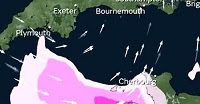
France’s Met Office named the storm that is set to bring strong winds to Cornwall and other parts of the South West coast this evening (October 31).
Storm Claudio sweeps in from northern France, causing disruption across some coastal parts of the UK, according to the Met Office.
Forecasters are expecting the region to see gusts of speeds between 50mph and 60mph. The storm has been named by Meteo France, and is set to make its way over the Channel Islands and English Channel.
The South East of England is also braced for strong winds overnight. The gusts will gradually head eastwards before reaching Dover at around 3am tomorrow (November 1).
According to the report, four departments in France, were placed on orange vigilance for high winds in the early morning, while strong gusts are expected during the evening.
The Met Office said in a tweet: “Storm #Claudio has been named by @meteofrance.
“Very strong winds are likely in northern parts of France, the Channel Islands and the English Channel It also brings a risk of gusts of 50-60 mph to Cornwall this evening and to some coastal parts of SE England overnight.”
“The depression Claudio leads to a clear strengthening this evening and this night on the north-west of the country with gusts greater than 100 km / h”, warns Météo-France .
The Channel particularly affected
The meteorological institute indicates that a depression will form this Monday at the end of the afternoon and in the evening “between the near Atlantic and the entrance to the Channel”. Stormy showers are expected in the western half of France.
The Autan wind, coming from the southeast, should strengthen during the day with peaks expected at 70-80 km / h in the region and up to 90 to 100 km / h at altitude in the Pyrenees.
The disturbances will then affect the English Channel, generating strong winds during the night and until Tuesday morning.
Up to 130 km/h
The situation will intensify on Monday evening for the departments concerned by orange vigilance, in particular on the Cotentin peninsula.
The gusts will go up to 90 to 110 km / h inland, but it is on the coasts that the phenomenon will be the most marked: the winds will then reach 110 to 130 km / h.
After the English Channel, the storm will head further north during the night and will persist on Tuesday in the form of gusts towards Pas-de-Calais.


Comments
Post a Comment